TAB. VI ASIAE, Arabiam Felicem, Carmaniam as Sinum Persicum comprehendens.
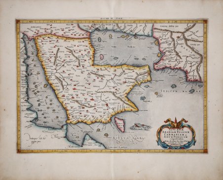
TAB. VI ASIAE, Arabiam Felicem, Carmaniam as Sinum Persicum comprehendens.
Payment methods
- PayPal
- Credit card
- Bank transfer
- Pubblica amministrazione
- Carta del Docente
Details
- Year of publication
- 1695
- Place of printing
- Amsterdam
- Size
- 480 X 339
- Engravers
- MERCATOR (Kremer) Gerard
- Inscription description
- Tibbetts 39. Al Ankary 262. McMinn 15.
Description
Mappa tolemaica della regione, originalmente preparata per illustrare il ' Cl. Ptolemaei Alexandrini, Geographiae Libri Octo, ' pubblicato prima a Colonia da Gottfried von Kempen (1578), ristampato dallo stesso editore nel 1584 (Van der Krogt 1, 502) e poi da Isaac Elsevier per il ' Theatrum Geographiae veteris ' di Petrus Bertius (Leyden 1618). Di tutte le edizioni di Tolomeo, quella di Gerard Kremer (Mercatore), pubblicata nel 1578, e forse tecnicamente la più bella. A questo punto la ' Geografia ' di Tolomeo perdeva pero ogni pretesa di “attualità”, laddove lo scopo di Mercatore era quello di produrre un atlante del mondo classico che servisse da complemento al suo atlante moderno (per tale ragione egli aveva tentato di recuperare la forma originale dell’atlante tolemaico, scartandone le moderne accrezioni). L’opera è celebre anche per la sua longevità, poiché le lastre originali risultavano ancora in uso nel 1730, oltre centocinquanta anni dopo la loro incisione. Esemplare tratto dalla ' Tabulae geographicae Cl: Ptolemei ' di François Halma, stampata tra Utrecht, Amsterdam e Leida nel 1695, 1698, 1704 (2 tirature) e 1730.Le lastre sono emendate e i cartigli completamenti cambiati; più piccoli e realizzati sopra i precedenti – abrasi – lasciando ampie aree bianche sulla stampa. La carta di Mercatore è stata una pietra miliare nella mappatura della Penisola arabica, essendo l'ultima edizione pubblicata di Tolomeo e senza dubbio la più studiata e approfondita di tutte le edizioni dal suo autore. In origine, Tolomeo si era basato sui resoconti di viaggiatori e marinai e, sebbene le informazioni fossero di seconda mano e spesso imprecise, rappresentavano il resoconto più avanzato della geografia mondiale dell'epoca. Nel caso dell'Arabia, Tolomeo sovrastimò sia l'ampiezza della parte meridionale dell'Arabia sia le dimensioni e la forma del Golfo Persico. L'Arabia Petrea e l'Arabia Deserta sono entrambe collocate a nord e l'Arabia Felix è il termine applicato all'intera penisola, piuttosto che alle sue porzioni meridionali. Acquaforte su rame, finemente colorata a mano, in perfette condizioni. Eearly and scarce map of present day Saudi Arabia, Qatar, United Arab Emirates, Yemen, and Oman. ' Ptolemaic map prepared for the ' Cl. Ptolemaei Alexandrini, Geographiae Libri Octo, ' first published in Cologne by Gottfried von Kempen (1578) and then reprinted by the same publisher in 1584 (Van der Krogt 1, 502) and then by Isaac Elsevier for the Petrus Bertius’ ' Theatrum Geographiae veteris ' (Leyden 1618). Mercator's interpretation of the 28 Ptolemaic text was possibly one of the truest undertaken up until that time. He had spent 13 years researching, drawing and engraving the maps at much commercial sacrifice to himself, having seen Ortelius's ' Theatrum ' and De Jodes ' Speculum ' published, to become both technical and commercial successes. In later life he devoted himself to his edition of the maps in Ptolemy's ' Geographia, reproduced in his own engraving as nearly as possible in their original form. The work is also famous for its longevity, since the original plates were still in use in 1730, over one hundred and fifty years after their engraving. Example taken from the ' Tabulae geographicae Cl: Ptolemei ' by François Halma, printed between Utrecht, Amsterdam and Leiden in 1695, 1698, 1704 (2 printings) and 1730. The plates are amended and the cartouches completely changed; smaller and made over the previous ones - erased - leaving large white areas on the print. Mercator's map was a landmark in the mapping of the Arabian Peninsula, being the last published edition of Ptolemy and without question the most heavily researched and studied of all editions by its maker. Ptolemy had originally drawn on the accounts of travelers and sailors and though the information was secondhand and often inaccurate it represented the most advanced account of the world's geography at that time. In the case of Arabia, Ptolemy overestimated both the width of the southern part of Arabia and the size and shape of the Persian Gulf. Arabia Petrea and Arabia Deserta are both placed in the north and Arabia Felix is the term applied to the whole peninsula, rather than to the southern portions of it. ' Copperplate with fine later hand colour, very good condition. Cfr. Tibbetts 39. Al Ankary 262. McMinn 15.