Details
Place of printing
Venezia
Engravers
RUSCELLI Girolamo
Description
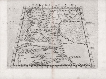
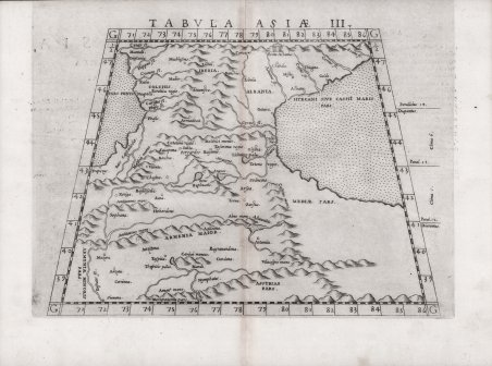
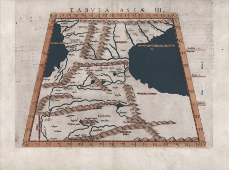
Mappa a proiezione trapezoidale di Ruscelli; si basa sul lavoro di Tolomeo e Giacomo Gastaldi e raffigura la regione tra il Mar Nero e il Mar Caspio, si estende nel territorio del Medio Oriente e fino alla Mesopotamia. La Colchide è al suo posto sulla costa del Mar Nero e una vasta area a est dell'Armenia è denominata come Assiria. L'Albania caucasica è al suo posto a nord-ovest del Mar Caspio, con il vicino Regno di Iberia a ovest. Centrata sull'attuale Georgia orientale, confinava con la Colchide a ovest, l'Albania caucasica a est e l'Armenia a sud. La sua popolazione, gli iberici, formava il nucleo dei kartveliani (cioè georgiani). Vicino all'estremità orientale della catena del Caucaso si apre una gola non lontano dalla riva del Caspio; questo è il passo Darband, chiamato dagli antichi le Porte dell'Albania e le Porte del Caspio. Ruscelli l'ha etichettata come "le porte dell'Albania" insieme a una vignetta di un edificio senza dubbio destinato a rappresentare le porte. La Cappadocia, che si trova nella Turchia centrale, viene erroneamente indicata sulla costa sud-orientale del Mar Nero. Le montagne del Caucaso sono rappresentate pittoricamente e molti sistemi fluviali sono indicati. Carta tratta dalla ' Geographia di Claudio Tolomeo, a cura di Girolamo Ruscelli, pubblicata in Venezia in più edizioni tra il 1561 ed il 1598. La carta è basata sulla “Geografia” di Giacomo Gastaldi (1548), che probabilmente disegnò personalmente anche queste mappe, che vennero incise dai fratelli Livio e Giulio Sanuto. La peculiarità di queste mappe è che sono incise due per lastra e successivamente tagliate; questo il motivo per cui il segno del rame appare solo in tre lati della mappa. Il testo del Ruscelli e le sue carte sono considerate come il miglior atlante moderno fino alla prima versione del ' Theatrum ' ' Orbis Terrarum ' di Abraham Ortelius (1570). Solo la loro larga diffusione ne impedisce una valutazione sostenuta nel mercato antiquario. L'opera infatti ebbe una prima stesura nel 1561, stampata da Vincenzo Valgrisi che ne curò anche la ristampa del 1562. Tre sono le edizioni firmate da Giordano Ziletti (due nel 1564 e una del 1574), mentre nel 1597 viene edita dai fratelli Calignani. Tutte queste edizioni contengono 64 tavole. Nel 1598 e 1599 vengono alla luce le due edizioni curate da Giuseppe Rosaccio e stampate dagli Eredi di Melchior Sessa. Queste ultime due edizioni comprendono 69 tavole; sono infatti aggiunte la carta del planisfero e dei continenti di Rosaccio. Acquaforte e bulino, finemente colorata a mano, in ottimo stato di conservazione. This is a fine example of Ruscelli’s map on trapezoidal projection from his ' work La Geografia di Claudio Tolomeo Alessandrino. ' It is based on the work of Ptolemy, and Giacomo Gastaldi, and depicts the region between the The Black Sea and the Caspian Sea, extends into the territory of the Middle East and as far south as Mesopotamia. The map first appeared in the 1561 edition of Ruscelli's edition of Ptolemy's Geografia. Colchis is in its place on the Black Sea coast, and a large area to the east of Armenia, is labeled Assyriae. Caucasian Albania is in its place to the northwest of the Caspian Sea, with the neighboring Kingdom of Iberia to the west. Centered on present-day Eastern Georgia, it was bordered by Colchis in the west, Caucasian Albania in the east and Armenia in the south. Its population, the Iberians, formed the nucleus of the Kartvelians (i.e. Georgians). Close to the eastern end of the Caucasus range a defile opens up not far from the shore of the Caspian; this is the Darband pass, called the Gates of Albania and the Caspian Gates by the ancients. Ruscelli has labeled it ‘the Gates of Albania’ along with a vignette of an edifice no doubt intended to represent gates. Cappadocia, which is located in central Turkey is mistakenly shown on the southeastern coast of the Black Sea. The Caucasus Mountains are depicted pictorially and many river systems are denoted. Both seas are stippled. Italian text on the verso describes the areas depicted on the map. Map taken from ' Geographia di Claudio Tolomeo ' edited by Girolamo Ruscelli, published in Venice in several editions between 1561 and 1598. The maps is based on the ' Geografia ' by Giacomo Gastaldi (1548), who probably also personally drew these maps, which were engraved by the brothers Livio and Giulio Sanuto. The peculiarity of these maps is that they are engraved two for plate and subsequently cut; this is why the copper sign only appears on three sides of the map. Ruscelli's text and his maps are considered to be the best modern atlas up to the first version of Abraham Ortelius' ' Theatrum Orbis Terrarum ' (1570). Only their widespread diffusion prevents a sustained evaluation in the antiquarian market. In fact, the work had a first edition in 1561, printed by Vincenzo Valgrisi who also edited the 1562 reprint. There are three editions signed by Giordano Ziletti (two in 1564 and one in 1574), while in 1597 it was published by the Calignani brothers. All these editions contain 64 plates. In 1598 and 1599 the two editions edited by Giuseppe Rosaccio and printed by the heirs of Melchior Sessa came to light. These last two editions include 69 plates; in fact, Rosaccio's map of the planisphere and continents has been added. Etching and engraving with finel later hand colour, in good condition. Cfr.

 Find out how to use
 Find out how to use