Tabula Asiae XII
Tabula Asiae XII | Prints | Münster Sebastian
Tabula Asiae XII
Tabula Asiae XII | Prints | Münster Sebastian
Payment methods
- PayPal
- Credit card
- Bank transfer
- Pubblica amministrazione
- Carta del Docente
Details
- Year of publication
- 1540
- Place of printing
- Basilea
- Size
- 340 X 250
- Engravers
- Münster Sebastian
Description
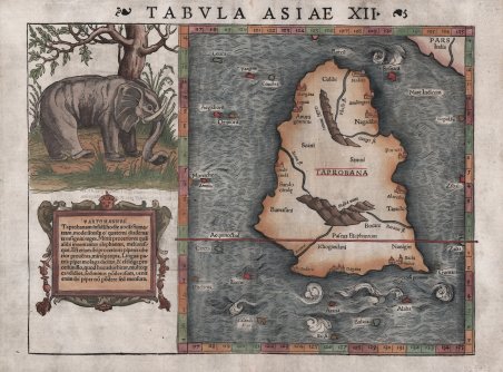
Esemplare finemente colorato della carta di Munster di Taprobana, l'isola di Ceylon, talvolta confusa con Sumatra nelle prime mappe. In alto a sinistra si trova una superba xilografia del Pascua Elephantum (un elefante al pascolo) che Tolomeo scrive nella sua Geographia di aver visto alla base dei Monti Malli. In basso a sinistra si trova un cartiglio decorativo che include una nota che indica che l'isola era una ricca fonte di avorio. Nell'antichità lo Sri Lanka era conosciuto con diversi nomi: Tolomeo lo chiamava Taprobana, gli arabi Serendib, i portoghesi Ceilo e gli inglesi Ceylon. Situato al centro di numerose rotte commerciali attraverso l'Oceano Indiano, l’odierno Sri Lanka è sempre stato un importante collegamento commerciale tra est e ovest. In quanto grande esportatore di cannella, i commercianti arabi e cinesi frequentavano l'isola fin dai tempi più antichi ed era una tappa importante per i mercanti sulla rotta marittima tra Asia ed Europa. Tra i cartografi medievali esisteva una grande confusione sull'identità delle isole di Taprobana e Sumatra, dovuta principalmente alle descrizioni dei testi antichi che affermavano che Taprobana era l'isola più grande del mondo. Questa affermazione fu poi contraddetta da Marco Polo nel suo Il Milione, in cui affermava che era Giava Minore (Sumatra) ad essere in realtà l'isola più grande. Poiché Sumatra era praticamente sconosciuta alla maggior parte dei cartografi medievali, la loro preoccupazione principale era la collocazione di Taprobana sulle mappe. Invariabilmente era posizionata in modo errato al largo della costa sud-orientale dell'Arabia, ma quando alla fine del XIII secolo furono resi noti i resoconti di Marco Polo, i limiti orientali dell'Oceano Indiano si ampliarono notevolmente e la questione dell'identità delle isole divenne più critica per i cartografi. I portoghesi arrivarono sull'isola nel 1505 e nel 1518 avevano costruito un forte a Colombo, consentendo loro di controllare le aree costiere strategiche che avevano precedentemente conquistato. Una volta copiate le informazioni e le carte portoghesi, la posizione di Ceylon e la confusione con Sumatra furono corrette. Tuttavia, alcuni studiosi ritengono che sia in realtà una rappresentazione dell'isola di Sumatra. Le isole circostanti raffigurate, sono rappresentate nella posizione delle odierne Nias, Enggano e Mentawis. La terra nell'angolo in alto a destra corrisponde alla Malesia; diverse città e villaggi si trovano collocati vicino alle attuali città di Lampung, Medan, Sibolga e Banda Aceh. Si trovano anche montagne e corsi d'acqua, anch'essi molto vicini all’attuale rappresentazione idrografica di Sumatra. ' Carta tratta dalla ' Geographia universalis, vetus et nova, complectens. Claudii Ptolemaei Alexandrini Ennarationis libros VIII, pubblicata per la prima volta nel 1540 a Basilea da Heinrich Petri, figliastro di Münster e suo fidatissimo stampatore. Il volume è illustrato da 27 carte costruite seguendo le indicazioni di Tolomeo, a cui si affiancano 21 carte “moderne”, delineate in base alle recenti scoperte geografiche. La Geographia di Münster ebbe un notevole successo, e Petri la ristampò l'anno seguente (1541) e quello successivo ancora. Aumentate di sei le carte moderne, tra le quali la Carta Marina di Olao Magnus descrittiva della Scandinavia, l'editore la ristampò ancora nel 1545, nel 1551 e infine nel 1552, sempre con 54 carte geografiche, ma con la sostituzione della Pomerania al posto del Lago di Costanza. Alla scomparsa di Münster l’opera non venne più ristampata; alcune delle carte furono invece utilizzate da Heinrich Petri per le edizioni postume della Cosmographiae Universalis. Le matrici lignee, debitamente emendate, furono poi utilizzate per il Rerum Geographicarum dello Strabo, edizione stampata a Basileae: Ex Officina Henricpetriana, 1571 Mense Augusto. Silografia, finemente colorata a mano, in ottimo stato di conservazione. Bibliografia Moreland. Finely colored example of Munster's map of Taprobana, the island of Ceylon, which was sometimes confused with Sumatra on early maps. In the top left is a superb woodcut of the Pascua Elephantum (an elephant at pasture) which Ptolemy wrote in his Geographia, of seeing at the base of the Malli Mountains. In the lower left is a decorative cartouche which includes a note indicating that the island was a rich source of ivory. In ancient times, Sri Lanka was known by various names, Ptolemy named it Taprobana, the Arabs Serendib, the Portuguese called it Ceilo and the British Ceylon. Situated at the centre of numerous trade routes through the Indian Ocean, Sri Lanka was always an important trading link between east and west. As a major exporter of cinnamon, Arab and Chinese traders had frequented the island since early times and it served as an important stop for merchants on the maritime route between Asia and Europe. Much confusion existed among medieval mapmakers as to the identities of the islands of Taprobana and Sumatra which arose primarily from the descriptions in the ancient texts which stated that Taprobana was the largest island in the world. This was later contradicted by Marco Polo in his Il Milione in which he stated that it was Java Minor (Sumatra) that was in fact the largest island. As Sumatra was virtually unknown to most medieval mapmakers their primary concern was the placement of Taprobana on maps. Invariably it was incorrectly positioned off the southeast coast of Arabia but once the accounts of Marco Polo were revealed at the end of the thirteenth century, the eastern limits of the Indian Ocean were greatly expanded and the question as to the identity of the islands became more critical for mapmakers. The Portuguese arrived on the island in 1505 and by 1518 had built a fort in Colombo, enabling them to control strategic coastal areas they had previously captured. Once Portuguese information and charts were copied, the position of Ceylon and the confusion with Sumatra was corrected. Although, some scholars believe it is actually a depiction of ' the island of Sumatra. ' The surrounding islands are located near where Nias, Enggano and Mentawis are relative to Sumatra. The land in the upper-right corner is correct for Malaysia. Several towns and village are located (close to present cities of Lampung, Medan, Sibolga and Banda Aceh. ' Mountains and waterways are also located - also very near where they are found today. Map taken from the ' Geographia universalis, vetus et nova, complectens. Claudii Ptolemaei Alexandrini Ennarationis libros VIII, ' published for the first time in 1540 in Basel by Heinrich Petri, stepson of Münster and his trusted printer. The book is illustrated by 27 maps built following the indications of Ptolemy, which are flanked by 21 "modern" maps, outlined on the basis of recent geographical discoveries. The ' Geographia ' of Münster was a great success, and Petri reprinted it the following year (1541) and then in 1542. Having increased the number of modern maps by six, including the ' Carta Marina ' of Olao Magnus describing Scandinavia, the publisher reprinted it again in 1545, in 1551 and finally in 1552, still with 54 maps, but with the substitution of ' Pomerania ' in place of ' Lake Constance. At the death of Münster the work was not reprinted; some of the maps were instead used by Heinrich Petri for the posthumous editions of the ' Cosmographiae Universalis. The woodblock of the maps, duly amended, were used for the ' Rerum Geographicarum ' of Strabo, edition printed in ' Basileae: Ex Officina Henricpetriana, 1571 Mense Augusto. Woodcut with fine later hand colour, in very good condition. References Moreland p.82, 302, Parry p.65-67, Shirley p.76, Suarez (A) p.101. ' ' Cfr.
