Tabula Indiae X
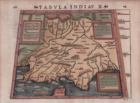
Tabula Indiae X
Payment methods
- PayPal
- Credit card
- Bank transfer
- Pubblica amministrazione
- Carta del Docente
Details
- Year of publication
- 1571
- Place of printing
- Basilea
- Size
- 340 X 270
- Engravers
- Münster Sebastian
Description
Visione tolemaica dell'India, definita dall'Indo a ovest e dal Gange a est. Il subcontinente è gravemente troncato e il Pars Toprobanae (Sri Lanka) appare dove dovrebbe estendersi la penisola. La mappa è piena di fiumi, catene montuose e antichi toponimi. I fiumi Indo e Gange sono gli unici elementi riconoscibili. Testo latino sul verso. La carta viene preparata per la Geographia universalis, vetus et nova, complectens. Claudii Ptolemaei Alexandrini Ennarationis libros VIII, pubblicata per la prima volta nel 1540 a Basilea da Heinrich Petri, figliastro di Münster e suo fidatissimo stampatore. Secondo Karrow, il titolo a stampa su questa carta indica che proviene dall'edizione del 1571 del Rerum Geographicarum di Strabo, anch'esso pubblicata da Heinrich Petri. L'edizione del 1540 della Geographia ha il titolo “Tabula Asiae X”. La Geographia universalis è illustrata da 27 carte costruite seguendo le indicazioni di Tolomeo, a cui si affiancano 21 carte “moderne”, delineate in base alle recenti scoperte geografiche. La Geographia di Münster ebbe un notevole successo, e Petri la ristampò l'anno seguente (1541) e quello successivo ancora. Aumentate di sei le carte moderne, tra le quali la Carta Marina di Olao Magnus descrittiva della Scandinavia, l'editore la ristampò ancora nel 1545, nel 1551 e infine nel 1552, sempre con 54 carte geografiche, ma con la sostituzione della Pomerania al posto del Lago di Costanza. Alla scomparsa di Münster l’opera non venne più ristampata; alcune delle carte furono invece utilizzate da Heinrich Petri per le edizioni postume della Cosmographiae Universalis. Le matrici lignee, debitamente emendate, furono poi utilizzate per il Rerum Geographicarum dello Strabo, edizione stampata a Basileae: Ex Officina Henricpetriana, 1571 Mense Augusto. Silografia, magnifica coloritura a mano, in ottimo stato di conservazione. ' Ptolemaic view of India, defined by the Indus in the west and the Ganges in the east. The subcontinent is severely truncated and ' Pars Toprobanae ' (Sri Lanka) appears where the peninsula should extend. The map is filled with rivers, rope-like mountain ranges and ancient place names. The Indus and Ganges rivers are about the only recognizable features. Latin text on verso. This map appeared in Sebastian Munster’s Geographia universalis, vetus et nova, complectens. Claudii Ptolemaei Alexandrini Ennarationis libros VIII, ' published for the first time in 1540 in Basel by Heinrich Petri, stepson of Münster and his trusted printer. According to Karrow, the letterpress title on this map indicates it comes from the 1571 edition of Strabo Rerum Geographicarum, also published by Heinrich Petri. The 1540 edition of the Geographia has the title, "Tabula Asiae X". The Geographia universalis is illustrated by 27 maps built following the indications of Ptolemy, which are flanked by 21 "modern" maps, outlined on the basis of recent geographical discoveries. The ' Geographia ' of Münster was a great success, and Petri reprinted it the following year (1541) and then in 1542. Having increased the number of modern maps by six, including the ' Carta Marina ' of Olao Magnus describing Scandinavia, the publisher reprinted it again in 1545, in 1551 and finally in 1552, still with 54 maps, but with the substitution of ' Pomerania ' in place of ' Lake Constance. At the death of Münster the work was not reprinted; some of the maps were instead used by Heinrich Petri for the posthumous editions of the ' Cosmographiae Universalis. The woodblock of the maps, duly amended, were used for the ' Rerum Geographicarum ' of Strabo, edition printed in ' Basileae: Ex Officina Henricpetriana, 1571 Mense Augusto. Woodcut, with fine later hand colour, in excellent condition. Cfr.