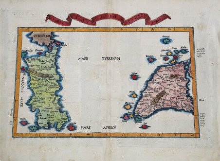
Tabula VII Europae
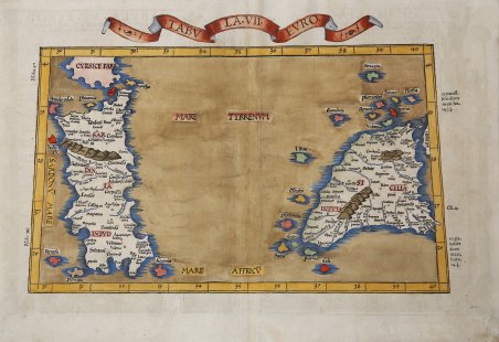
Tabula VII Europae
Payment methods
- PayPal
- Credit card
- Bank transfer
- Pubblica amministrazione
- Carta del Docente
Details
- Year of publication
- 1525
- Place of printing
- Strasburgo
- Size
- 555 X 410
- Engravers
- FRIES Laurent
- Languages
- Italian
Description
Importante mappa della Sardegna e della Sicilia. ' La mappa è basata sulla mappa di Waldseemuller, pubblicata per la prima volta nella Geographia di Strasburgo del 1513. La settima tavola d'Europa rappresenta la Sardegna e la Sicilia con gli attributi tipici di queste due isole in tutte le carte tolemaiche: la Sardegna dalla forma tozza e allungata, con l'unica catena dei Menomeni montes (rappresentata da cinque tronchi di cono affiancati) e pochi fiumi; la Sicilia in forma triangolare con i suoi Cratas mons e le fiamme che identificano il vulcano Etna. Non mancano anche i nomi delle antiche popolazioni, completati da due tabelle che, all'interno del disegno, riportano notizie sui popoli e le città delle due isole. La prima edizione della "Geographia" di Tolomeo curata da Fries fu pubblicata a Strasburgo nel 1522, con le carte che furono copiate e nuovamente incise da quelle di Martin Waldseemüller dell'edizione di Tolomeo del 1520 e testo a cura di Pirckheimer. Nel 1525 viene stampata una seconda edizione a Strasburgo. Alla scomparsa del Fries e del Gruninger, le matrici furono acquistate dai fratelli Melchior e Gaspar Treschel che ne stampano una terza edizione a Lione nel 1535. Per il testo i due editori si servirono della supervisione di Michael Servetus, che curò la revisione del testo del Pirckheimer. Infine, nel 1541, Gaspare Treechsel pubblica a Vienne, nel Delfinato, questa quarta edizione, sempre con testo di Servetus. In questa edizione, rispetto alla prima di Strasburgo del 1522, il testo subì numerose modifiche, correzioni e aggiunte, ma i legni non furono modificati. Esemplare tratto dall’edizione del 1525, del "Claudii Ptolemaei Alexandrini Geographicae Enarrationis".Xilografia, finemente colorata a mano, piccolo restauro nella piega centrale e negli angoli inferiori del margine bianco, piccole ossidazioni, per il resto in buono stato di conservazione. Important early map of Sardinia and Sicily. The map is based upon Waldseemuller's Ptolemaic map, first published in 1513. The seventh table of Europe depicts Sardinia and Sicily with the attributes typical of these two islands in all Ptolemaic charts: the squat, elongated Sardinia with the single chain of Menomeni montes (represented by five truncated cones side by side) and a few rivers; the triangular-shaped Sicily with its Cratas mons and flam¬es identifying the volcano Etna. There is also no shortage of names of ancient peoples, complemented by two tables within the drawing that give information about the peoples and cities of the two islands. The first edition of Ptolemy's ' Geographia ' edited by Fries was published in Strasbourg in 1522, with maps that were copied and re-engraved from those of Martin Waldseemüller of the 1520 edition of Ptolemy and text edited by Pirckheimer. In 1525 a second edition was printed in Strasbourg. At the death of Fries and Gruninger, the plates were purchased by the brothers Melchior and Gaspar Treschel, who printed a third edition in Lyon in 1535. For the text, the two editors used the supervision of Michael Servetus, who edited Pirckheimer's text. Finally, in 1541, Gaspare Treechsel published in Vienne, in the Dauphiné, this fourth edition, again with Servetus' text. In this edition, compared to the first edition of Strasbourg in 1522, the text underwent numerous changes, corrections and additions, but the wood-blocks were not changed. ' Example from Claudii Ptolemaei Alexandrini Geographicae Enarrationis, 1525. Woodcut, colored by hand, small restoration in the middle fold and at the lower white margins, some foxing, otheriwise good condition. Cfr.