Tavola della oriental regione dell' Asia, che comprende l'estreme terre, & regni di quella
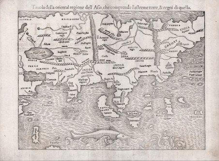
Tavola della oriental regione dell' Asia, che comprende l'estreme terre, & regni di quella
Payment methods
- PayPal
- Credit card
- Bank transfer
- Pubblica amministrazione
- Carta del Docente
Details
- Year of publication
- 1540
- Place of printing
- Basilea
- Size
- 335 X 270
- Engravers
- Münster Sebastian
- Inscription description
- Parry, The Cartography of the East Indian Islands, pp.65-68, pl. 3.8
Description
La mappa mostra l'Asia dal Mar Caspio e dal Golfo Persico al Pacifico. L'Oceano Pacifico mostra un arcipelago di 7448 isole, un precursore per una migliore comprensione dell'Asia sudorientale, che è in gran parte non riconoscibile, anche se Giava, il Borneo, le Molucche e diverse altre isole sono sono correttamente denominate. La mappa non include Giappone, che appare sulla mappa dell'America dello stesso autore. Anche la costa nordorientale dell'Asia è omessa. Anche se in gran parte basata sul lavoro di Tolomeo, la mappa incorpora alcune delle più recenti scoperte portoghesi. ' I contorni del subcontinente indiano, tra i fiumi Indo e Gange, sono ora in una forma più riconoscibile, con "Zaylon" (Sri Lanka) correttamente mostrato come un'isola. L'avamposto portoghese di Goa e Calcutta, il primo luogo dove sbarcò Vasco da Gama nel 1497, sono raffigurati. Ad est "Taprobana" è anche disegnato come pure "Sumatra". È rappresentata anche "Moloca", centro del commercio dell'isola spezia e l'oggetto di notevoli conflitti tra Spagna e Portogallo. La risoluzione della controversia fu lo scopo ufficiale dell'epico viaggio di Magellano. Il trattamento di "Cathay" (Cina) è coerente con gli scritti di Marco Polo e di altri viaggiatori veneziani. Carta tratta dalla ' Geographia universalis, vetus et nova, complectens. Claudii Ptolemaei Alexandrini Ennarationis libros VIII, pubblicata per la prima volta nel 1540 a Basilea da Heinrich Petri, figliastro di Münster e suo fidatissimo stampatore. Il volume è illustrato da 27 carte costruite seguendo le indicazioni di Tolomeo, a cui si affiancano 21 carte “moderne”, delineate in base alle recenti scoperte geografiche. La ' Geographia ' di Münster ebbe un notevole successo, e Petri la ristampò l'anno seguente (1541) e quello successivo ancora. Aumentate di sei le carte moderne, tra le quali la ' Carta Marina ' di Olao Magnus descrittiva della Scandinavia, l'editore la ristampò ancora nel 1545, nel 1551 e infine nel 1552, sempre con 54 carte geografiche, ma con la sostituzione della ' Pomerania ' al posto del ' Lago di Costanza. Alla scomparsa di Münster l’opera non venne più ristampata; alcune delle carte furono invece utilizzate da Heinrich Petri per le edizioni postume della ' Cosmographiae Universalis. Le matrici lignee, debitamente emendate, furono poi utilizzate per il ' Rerum Geographicarum ' dello Strabo, edizione stampata a ' Basileae: Ex Officina Henricpetriana, 1571 Mense Augusto. Silografia, in ottimo stato di conservazione. Nice example of this first printed map of the Asia, by Sebastian Munster.The map shows Asia from the Caspian Sea and Persian Gulf to the Pacific. The Pacific Ocean shows an archipelago of 7448 islands, a forerunner to the better understanding of Southeast Asia, which is largely unrecognizeable, although Java Minor and Major, Porne (Borneo), Moluca and several other islands are named. The map does not include Japan, which appears on the map of America. The northeastern coast of Asia is also omitted. The map also includes a large sea monster and mermaid type creature.Although largely based on Ptolemy's work, the map incorporates some of the more recent Portuguese discoveries. The outlines of the Indian subcontinent, between the Indus and the Ganges rivers are now in a more recognizable form, with "Zaylon" (Sri Lanka) correctly shown as an island. The Portuguese outpost sof Goa and Calicut, the first place where Vasco da Gama landed in 1497, are depicted. Further to the east "Taprobana" is also designated as "Sumatra.". The Portugese trading port of "Malaqua" is shown. Java is depicted as two separate islands. "Moloca," center of the spice island trade and the object of considerable conflict between Spain and Portugal is shown. The resolution of the dispute was the official purpose of Magellan's epic circumnavigation. The treatment of "Cathay" (China) is consistent with the writings of Marco Polo and other Venetian travellers. Map taken from the ' Geographia universalis, vetus et nova, complectens. Claudii Ptolemaei Alexandrini Ennarationis libros VIII, ' published for the first time in 1540 in Basel by Heinrich Petri, stepson of Münster and his trusted printer. The book is illustrated by 27 maps built following the indications of Ptolemy, which are flanked by 21 "modern" maps, outlined on the basis of recent geographical discoveries. The ' Geographia ' of Münster was a great success, and Petri reprinted it the following year (1541) and then in 1542. Having increased the number of modern maps by six, including the ' Carta Marina ' of Olao Magnus describing Scandinavia, the publisher reprinted it again in 1545, in 1551 and finally in 1552, still with 54 maps, but with the substitution of ' Pomerania ' in place of ' Lake Constance. At the death of Münster the work was not reprinted; some of the maps were instead used by Heinrich Petri for the posthumous editions of the ' Cosmographiae Universalis. The woodblock of the maps, duly amended, were used for the ' Rerum Geographicarum ' of Strabo, edition printed in ' Basileae: Ex Officina Henricpetriana, 1571 Mense Augusto. Woodcut, in excellent condition. Cfr. Parry, The Cartography of the East Indian Islands, pp.65-68, pl. 3.8