Turcici Imperii Imago

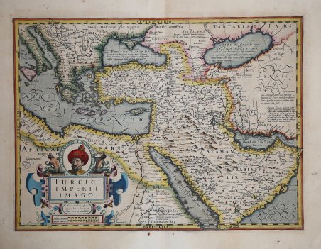
Turcici Imperii Imago
Payment methods
- PayPal
- Credit card
- Bank transfer
- Pubblica amministrazione
- Carta del Docente
Details
- Year of publication
- 1606
- Place of printing
- Amsterdam
- Size
- 460 X 370
- Engravers
- HONDIUS Jodocus
- Inscription description
- G. R. Tibbets, Arabia in Early Maps, p. 63 n.62. Dimensioni 460x370.
Description
Dettagliata carta geografica che descrive l’Impero Ottomano, nei territori compresi tra i Balcani, la Turchia, il Levante, l’Arabia e il Nord Africa. I dettagli cartografici derivano dalla mappa del Mercator; i dettagli della penisola arabica sono decisamente più corretti che nelle mappe precedenti. Il decorativo cartiglio a sinistra contiene il ritratto del sultano Mahomet, imperatore dei turchi. La carta è inserita, a partire da 1606, nell'Atlas sive Cosmographicae Meditationes de Fabrica Mundi et Fabricati figura di Hondius e ristampata in tutte le successive edizioni. Nel 1604, Jodocus Hondius (1563-1612) - probabilmente tramite Cornelis Claesz - acquistò le matrici in rame dell'Atlas sive cosmographicae meditationes de fabrica mundi di Gerard Mercator all’asta. Aggiunse circa 40 mappe, comprese nuove mappe dei continenti e importanti mappe regionali delle Americhe, prima di pubblicare una nuova edizione dell’opera, nel 1606, in concorrenza con il Theatrum Orbis Terrarum di Ortelius. Poiché molte delle mappe erano più aggiornate, la raccolta di Mercator & Hondius sostituì effettivamente il Theatrum di Ortelius. ' L’atlante del 1606 include tutte le 107 mappe dell’edizione del 1595, oltre a 37 nuove mappe, abilmente incise dallo stesso Hondius. La seconda edizione della raccolta seguì già nel 1607/08, mentre la prima edizione in un’altra lingua, il francese, fu messa sul mercato nel 1609. Apparentemente questa fu considerata come la terza edizione, perché nel 1611 apparve l'Editio Quarta, con un totale di 150 mappe. Dopo la morte di Jodocus Hondius (1612) la sua vedova e i suoi figli continuarono la stampa dell’atlante. Jodocus Junior ( o Jodocus II, 1594-1629) produsse diverse ristampe tra il 1613 e il 1619, sempre con le stesse 150 mappe; nel 1619 furono invece aggiunte sei nuove mappe. Dopo il 1620 la pubblicazione venne curata da Hendrick (Henricus) Hondius (1597-1651), il secondo figlio di Jodocus senior. Varie edizioni apparvero, nel 1623, 1628 e 1630. Hendrick fu il primo ad apportare dei veri cambiamenti: nell’edizione del 1628 firmò alcune mappe di Mercatore con il proprio nome. Nel 1630, quando probabilmente stava già collaborando con suo cognato Johannes Janssonius, aggiunse nove nuove carte. Incisione in rame, coloritura antica con ritocchi di colore, in eccellente stato di conservazione. Edizione francese. Detailed map covering the Ottoman territories in Balkans, Anatolia, Levant, Arabia and North Africa published by Henricus Hondius in Atlas sive Cosmographicae Meditationes de Fabrica Mundi et Fabricati figura, in 1606, and it was also part of all the following editions. The details derive from Marcator’s map; those of the Arabic peninsula are definitely more correct than those of previous maps. This example has a decorative cartouche with the portrait of Ottoman Sultan Mahomet Turcorum Imperat. In 1604, Jodocus Hondius (1563-1612) – probably trought Cornelis Claesz - bought the copperplates of Mercator’s Atlas sive cosmographicae meditationes de fabrica mundi at the auction of Gerard Jr.’s effects. He added about 40 maps, including new maps of the Continents and important regional maps of the Americas, before publishing a new edition of the Atlas, in 1606, in competition with Ortelius’ Theatrum Orbis Terrarum. As many of the maps were more up-to-date, the Mercator-Hondius Atlas effectively superseded Ortelius’ Theatrum. ' This atlas from 1606 include all 107 maps from the 1595 edition, as well as 37 new maps, skillfully engraved by Hondius, of various authors. The second edition of the Mercator-Hondius atlas followed as soon as 1607/08. The first edition in another language, French, was put on the market in 1609. Apparently this one was regarded as the third edition, because in 1611 ' Editio Quarta ' appeared with a total of 150 maps. After the death of Jodocus Hondius in 1612 his widow and sons continued the publication of the ' Atlas. ' For instance Jodocus Junior (1594-1629) produced several new editions of the ' Editio Quarta ' between 1613 and 1619, each with the same 150 maps. Finally in 1619 the last edition of this atlas followed, to which six new maps were added. After 1620 the publication of the ' Atlas ' was continued by Henricus Hondius (ca. 1596/97-1651), the second son of Jodocus senior. Various editions appeared, in 1623, 1628 and 1630. Henricus Hondius was the first to make some real changes: in the 1628 edition he provided some Mercator maps with his own name. In 1630, when he was probably already cooperating with his brother-in- law Johannes Janssonius, Henricus added nine new maps. Copper engraving, contemporary colour with touches, in excellent condition. Cfr. G. R. Tibbets, Arabia in Early Maps, p. 63 n.62.