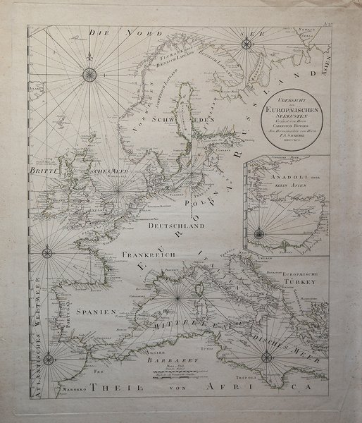
Ubersicht der Europaeischen Seekusten Verfasst von Herrn Carington Bowles Neu herausgegeben von heern F.A. Schraembl MDCCXCI

Ubersicht der Europaeischen Seekusten Verfasst von Herrn Carington Bowles Neu herausgegeben von heern F.A. Schraembl MDCCXCI
Payment methods
- PayPal
- Credit card
- Bank transfer
- Pubblica amministrazione
- Carta del Docente
Details
- Year of publication
- 1791
- Place of printing
- Vienna
- Size
- 490 X 600
- Engravers
- SCHRAEMBL Franz Anton
Description
Carta nautica dell’Europa tratta dall’atlante dello Schraembl. La carta delinea le coste della parte occidentale dell’Europa dalla Scandinavia al Mediterraneo, incluso il Nord Africa.La carta deriva dalla rarissima opere di Carington Bowles, stampata a Londra nel 1779.Il Mediterraneo orientale, con l’isola di Cipro, è raffigurato in un cartiglio nella parte destra della carta. Pubblicata a Vienna nell’ Allgemeiner Grosser Atlas. Franz Anton Schraembl (1751-1803) fu un cartografo viennese attivo nell'ultima parte del XVIII secolo. Schraembl, nato a Vienna, fondò il suo studio nel 1787, in collaborazione con il collega austriaco Franz Johann Joseph von Reilly (1766-1820), e nello stesso anno iniziò la sua grande opera, l'Allgemeiner Grosser Atlas. Questo ambizioso atlante di grande formato doveva basarsi solo sulle informazioni cartografiche più aggiornate disponibili e si basava sul lavoro di cartografi come D'Anville e di esploratori come Cook, Roberts e altri. L'atlante fu completato nel 1800, diventando il primo atlante mondiale austriaco. Purtroppo, l'opera ebbe una diffusione relativamente minima, forse a causa del suo costo elevato. Le scarse vendite, purtroppo, portarono Schraembl all'insolvenza. Alla fine, la sua attività si riprese un po' con la pubblicazione di una serie di materiali diversi, dalla letteratura ai libri d'arte. Quando Franz Anton morì nel 1803, l'azienda fu rilevata dalla vedova Johanna e dal fratello, l'incisore Karl Robert Schindelmayer. Dal 1825 l'azienda fu rilevata dal figlio Eduard Schraembl. Incisione in rame, coloritura coeva dei contorni, in eccellente stato di conservazione. Molto decorativa. This uncommon and interesting Austrian large sea chart of the waters surrounding Europe, is after Carrington Bowles. The European coasts are shown in greaqt detail and the interior of the continent is completely blank. Below the round title cartouche an inset map is placed, titled “Anadoli oder Klein Asien”, showing Turkey, Cyprus, the Middel East and Egypt. The sea chart is arrayed with rhumb lines radiating from six compass roses. Some light brown spotting concentrated in the center of Europe. This map was published in Vienna by Franz Anton Schraembl for his ' Allgemeiner Grosser Atlas. Franz Anton Schraembl (1751 - 1803) was a Vienna based cartographer working in the later part of the 18th century. Schraembl was burnin Vienna and founded his firm in 1787, partnering with fellow Austrian Franz Johann Joseph von Reilly (1766 - 1820), and began his great work, the ' Allgemeiner Grosser Atlas ' in the same year. This ambitious large format atlas was to be based upon only the most up-to-date cartographic information available and is based upo the work of cartographers like D'Anville and explorers such as Cook, Roberts, and others. The atlas was finally finished in 1800 but becoming the first Austrian world atlas. The work unfortunately enjoyed only relatively minimal circulation, possibly due to its high cost. The low sales, unfortunately, drove Schraembl into insolvency. His business eventually recovered somewhat with the publication of a diverse array of materials ranging from literature to art books. When Franz Anton died in 1803, the firm was taken over by his widow Johanna and her brother, the engraver Karl Robert Schindelmayer. From 1825 the firm was taken over by his son, Eduard Schraembl. Very good gondition. Cfr.