Umrisse der Pflanzengeographie
Umrisse der Pflanzengeographie
Payment methods
- PayPal
- Credit card
- Bank transfer
- Pubblica amministrazione
- Carta del Docente
Details
- Year of publication
- 1852
- Place of printing
- Hildburghausen
- Size
- 310 X 240
- Engravers
- MEYER Carl Joseph
Description
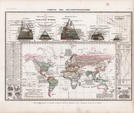
Questa tavola di “Lineamenti di Geografia Vegetale” è una copia della carta di Heirich Berghaus (pubblicata nel suo ' Physikalischer Atlas oder Sammlung von Karten ' del 1849) che illustrava la famosa opera di Alexander von Humboldt "Cosmos" (1845-1862). In questa illustrazione sono mostrate per la prima volta le relazioni altitudinali dalle Ande tropicali alla Lapponia. La parte inferiore della mappa contiene la "Distribuzione delle piante secondo le condizioni principali", quella superiore la "Distribuzione delle piante secondo la direzione verticale nelle zone calde, temperate e fredde". In alto a destra si trovano le "Curve di rapporto tra le monocotiledoni e le dicotiledoni nelle Alpi svizzere" e in basso a destra le "Statistiche grafiche delle famiglie di piante più importanti". Dal "Neueste Zeitungs-Atlas für Alte & Neue Erdkunde" di Carl Joseph Meyer (1796 – 1856) L’atlante venne pubblicato nel 1852 a Hildburghausen, Amsterdam e New York. Comprendeva 123 carte di geografia antica, moderna e di geografia fisica. Le mappe sono considerate tra le più dettagliate del XIX secolo, con informazioni minuziose che mostrano i confini politici e amministrativi, le città, i paesi, i canali, i forti, le strade, le ferrovie, i fiumi e le montagne. Incisione su acciaio, coloritura coeva dei contorni, lievi ossidazioni marginali, nel complesso in ottimo stato di conservazione. The map is a copy after the "Umrisse der Pflanzengeographie (Outlines of Plant Geography)" from the Physical Atlas by Heinrich Berghaus, which illustrates Alexander von Humboldt's famous work "Cosmos" (1845-1862). The altitudinal relationships from the tropical Andes to Lapland were shown for the first time ever in this illustration. The lower part of the map contains the "Distribution of plants according to the main conditions", the upper part the "Distribution of plants according to vertical direction in the hot, temperate and cold zones". At the top right are the "Ratio curves of the monocotyledons to the dicotyledons in the Swiss Alps", and at the bottom right are "Graphical statistics of the most prominent plant families". Taken form ' Neueste Zeitungs-Atlas für Alte & Neue Erdkunde ' With a engraved title page, index, and 123 steel engraving outline hand colored maps dated between 1849-1852. These atlas maps were produced in Hildburghausen, Amsterdam, and New York, and are considered some of the most detailed maps produced in the 19th Century. ' Atlas includes 123 maps of old geography, maps of modern geography, and maps of physical geography. The maps are of the highest Meyer quality, with detail information, showing political and administrative boundaries, cities, towns, canals, forts, roads, railroads, rivers and mountains. Steel-engraving, contemporary hand-coloring, light foxing, otherwise in very good condition. Cfr.