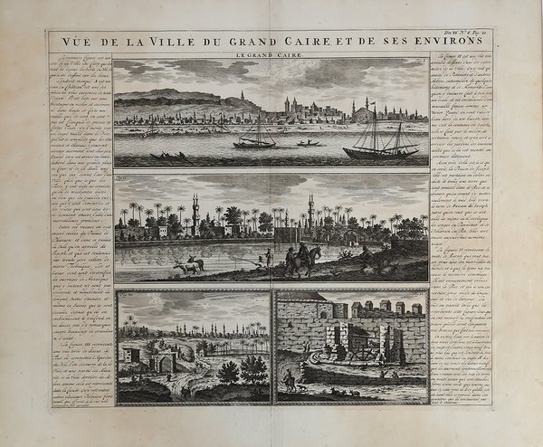
Vue de la Ville du Grand Caire, et de ses environs
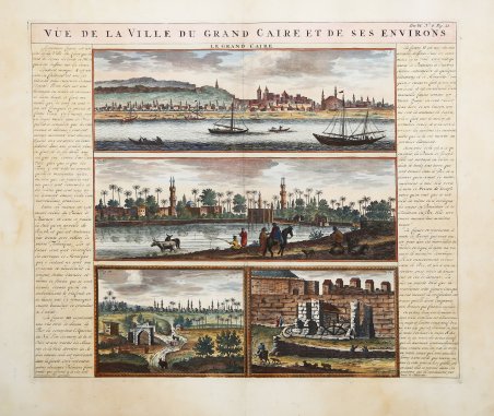
Vue de la Ville du Grand Caire, et de ses environs
Payment methods
- PayPal
- Credit card
- Bank transfer
- Pubblica amministrazione
- Carta del Docente
Details
- Year of publication
- 1708
- Place of printing
- Amsterdam
- Size
- 440 X 380
- Engravers
- CHATELAIN Henri Abraham
- Keyword
- - Africa -
- Languages
- Italian
Description
Questo attraente foglio presenta quattro splendide vedute del Cairo con la sua architettura e il trafficato fiume Nilo. Le vedute sono affiancate da un ampio testo in francese che descrive i dintorni, il commercio e la storia della regione. Tratta dall'Atlas Historique, pubblicato ad Amsterdam tra il 1705 e il 1720. L'atlante, in 7 volumi, è innovativo per la sua epoca perché combina le mappe geografiche con incisioni e informazioni di carattere storico, etnografico ed araldico. Incisione in rame, finemente colorata a mano, in ottimo stato di conservazione. Henri Abraham Chatelain (1684 - 1743) era un pastore ugonotto di origini parigine. È meglio conosciuto come cartografo olandese e più specificamente per il suo contributo cartografico nell’Atlas Historique ' in sette volumi, pubblicato ad Amsterdam tra il 1705 e il 1720. Innovativo per il suo tempo, l'Atlas Historique ' combinava incisioni e opere d'arte con studi di geografia, storia, etnologia, araldica e cosmografia. Alcuni studiosi suggeriscono che l'Atlas Historique ' non fu compilato esclusivamente da Henri Chatelain, come si crede comunemente, ma piuttosto fu un'impresa familiare che coinvolse Henri, suo padre Zacharie e suo fratello, sempre Zacharie. This attractive sheet features four great views of Cairo with its architecture and the busy Nile River. The views are flanked with extensive French text describing the vicinity, commerce and history of the region. Taken from Atlas Historique, published in Amsterdam between 1705 and 1720. Henri Abraham Chatelain (1684 - 1743) was a Huguenot pastor of Parisian origins. He is best known as a Dutch cartographer and more specifically for his cartographic contribution in the seminal seven volume ' Atlas Historique, published in Amsterdam between 1705 and 1720. Innovative for its time, the ' Atlas Historique ' combined fine engraving and artwork with scholarly studies of geography, history, ethnology, heraldry, and cosmography. Some scholarship suggests that the ' Atlas Historique ' was not exclusively compiled by Henri Chatelain, as is commonly believed, but rather was a family enterprise involving Henri, his father Zacharie and his brother, also Zacharie. Copper engraving, fine later hand colour, in excellent condition. Cfr.