Details
Place of printing
Amsterdam
Engravers
BLAEU Willem Janszoon
Description
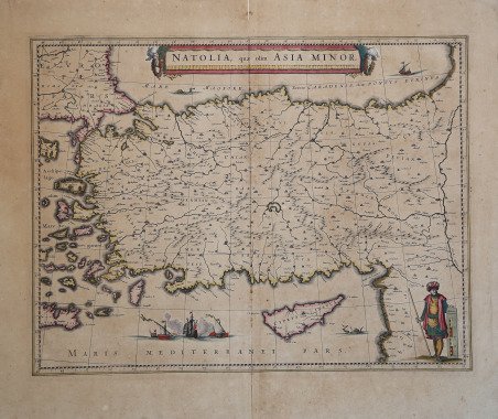
Fascinosa carta della Turchia e dell'ìsola di Cipro, con raffigurazione di una battaglia navale e di un personaggio in vesti turchesche. Pubblicata per la prima volta nel "Atlas Novus" la carta è parte di tutti gli atlanti di Willem, Johannes e Cornelis Blaeu. Esemplare con testo latino al verso. Willem Janszoon Blaeu, avviò nel 1599 la sua attività di costruttore di globi e strumenti astronomici ad Amsterdam. Nel 1630, dopo aver comprato alcune lastre dell’atlante del Mercator da Jodocus Hondius II, fu in grado di pubblicare un volume di 60 mappe con il titolo di ' Atlantis Appendix. Cinque anni dopo, pubblicò i primi due volumi del suo atlante ' Atlas Novus ' o ' Theatrum Orbis Terrarum, ' in sei libri. Dopo la sua morte, Joan (Johannes) continuò l’opera paterna, completando l’intera serie di sei volume dell’Atlas Novus ' intorno al 1655. Fu inoltre autore di un ' Atlas Maior sive Cosmographia Blaviana, in 12 volumi pubblicati nel 1662 -72. Incisione in rame, coloritura coeva, in ottime condizioni. This is an attractive c. 1640 map of Turkey or Asia Minor by Willem Janszoon Blaeu. It covers Turkey from the Aegean Sea east as far as the Euphrates River. Cyprus and some of the Aegean Islands are also included. The map is beautifully detailed, noting several important towns, cities, rivers, and topography. Mountains are beautifully rendered in profile. The important cities of Constantinople (Istanbul), Smyrna (Izmir) and Antioch are identified. The Ottoman Empire, at its peak, controlled the entire region during this period with Constantinople as its capital. In the middle part of the 17th century, after its period of growth, the Ottoman Empire would enter a period of gradual decline and stagnation. A beautifully illustrated sea battle in the Mediterranean depicts one of the many naval battles fought by the Ottomans. Another illustration of a sea monster is also featured in the bottom right quadrant. A beautifully engraved title banner adorns the top of the map, with a scale depicted in the bottom right quadrant. Later editions would include an illustration of a turbaned figure holding the scale. This map was issued in 1640 by Willem Janszoon Blaeu's Atlas Novus. Latin text on verso. Willem Janszoon Blaeu, started in 1599 his business as a builder of globes and astronomical instruments in Amsterdam. In 1630, after buying some plates of the Mercator atlas from Jodocus Hondius II, he was able to publish a volume of 60 maps under the title ' Atlantis Appendix. Five years later, he published the first two volumes of his atlas ' Atlas Novus ' or ' Theatrum Orbis Terrarum, in six books. After his death, Joan (Johannes) continued his father's work, completing the entire six-volume ' Atlas Novus ' series around 1655. He was also the author of an ' Atlas Maior sive Cosmographia Blaviana, in 12 volumes published in 1662 -72. Copperplate with contemporary hand colour, in good conditions. Cfr.

 Find out how to use
 Find out how to use